Hawai‘i Historical and Archaeological Research Project (H2ARP)
- Investigator/s:
- Dr. Michael Graves
Ms. Katherine Peck - Location:
- Kohala Peninsula, Hawai‘i Island, Hawai‘i
- Dates:
- On-going, 2006 through Spring and Summer 2022
Description
Read about the Hawaii Hibben Undergraduate Fellowship Opportunity
Click here for the Hawaii Hibben Undergraduate Fellowship Application 2022
Michael Graves, professor of Anthropology at the University of New Mexico is a specialist in Polynesian and Hawaiian archaeology, with a focus on the development of traditional Hawaiian agricultural practices in relation to the environmental and social contexts in which they occurred. Michael joined the Department of Anthropology at UNM in 2007, following 20 years at the University of Hawai‘i at Mānoa.
 (Photo credit, Jesse Stephen, University of Hawaiʽi.)
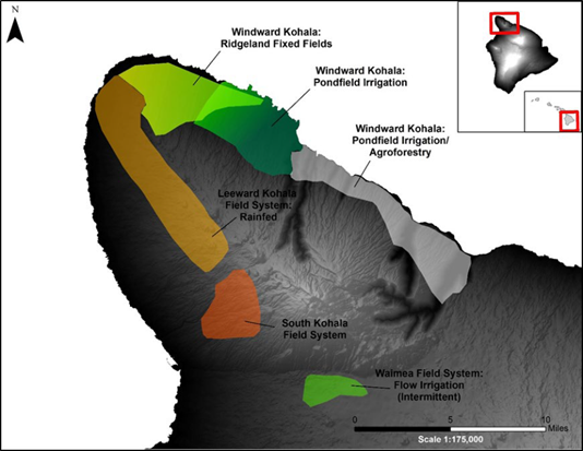
The Hawai‘i Historical and Archaeological Research Project (H2ARP) is a long term training and research program that provides archaeological field and historic archival experience focused on the cultural and natural resources of the moku (district) of Kohala, Hawai‘i Island. The main goal of the research program has been to describe and reconstruct traditional Hawaiian agricultural practices distributed across both the windward (wet) and leeward (dry) sides of the Kohala peninsula. We attempt to understand the interaction of geophysical and climatic parameters with resource distributions and the agricultural and engineering practices of Hawaiians that resulted in large-scale dry land farming (such as the Leeward Kohala Field System), the use of flow irrigation (the Waimea and South Kohala Field Systems) or pond field terrace systems (kalo loʻi, see below), the latter consist of networks of ditches (ʻauwai) transporting water from streams across impermanent drainages (ʻowāwa) or within smaller gulches (ʻaʻalu ) and valleys (kahawai). Kohala is unique in that these ditches sometimes extended across valley slopes to the dry ridge lands (kula) that separated these drainages.
 Hawaiians intimately understood the landscape and climatic conditions of Kohala and took advantage to develop dryland fields used mostly for cultivating uʻala (sweet potato) in a number of upland areas that lacked perennial streams. In other, better watered areas they cultivated kalo (taro) along with several other cultigens such as maiʽa (banana), ko (sugarcane), ʽulu (breadfruit), niu (coconut), ki (ti), and hala (pandanus).
(Photo: Location of major traditional Hawaiian agricultural systems distinguished by cultivation and irrigation practices in Kohala.)
Using remote sensing, historical documents as well as archaeological remains, we reconstruct the social and political dynamics at different scales of time and space as they played out in land use, tenure, and ownership from pre-European times to as recently as the mid-20th century. One goal of our training is to show students how it is possible to integrate information on the historical, archaeological and natural resources of the area with the least impact on the cultural resources of the area. We work closely with local communities and Native Hawaiian groups in developing research that meets their needs and reflects their concerns.
Mauka Kawaihae Study Area, Kohala, Hawaiʽi Island
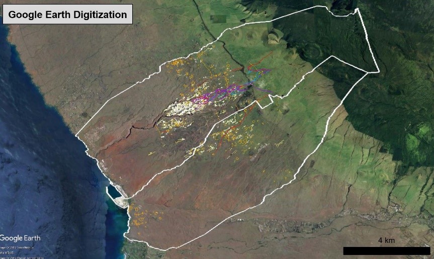
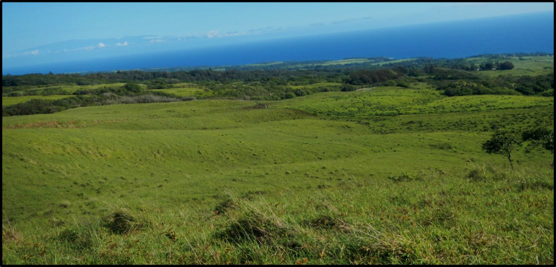
For her dissertation research, Katherine Peck (University of New Mexico), is focused on an upland (mauka) area in South Kohala, Hawaiʽi Island where a large dryland field system has been identified using satellite imagery. Current research includes fieldwork and geospatial studies of the upland South Kohala Field System (SKFS) in Kawaihae 1 and 2 Ahupuaʽa. Portions of this area are considered marginal for dryland farming, and yet the SKFS combines aspects of dryland and irrigated agriculture. (Photo: Satellite photograph of Kawaihae 1 and 2 Ahupuaʽa showing the location of the South Kohala Field System.)
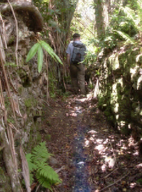
Katherine seeks to study the historical ecology of traditional agriculture that incorporates reticulate fixed field rock alignments and walls, along with networks of irrigation from upland perennial streams diverted through ditches (ʽauwai) and along small gullies to supply water to dryland fields at lower elevations. Work has also begun on documenting a series of traditional Hawaiian trails that cross the uplands of Kawaihae 1 Ahupuaʽa.
 Katherine’s research has been developed in collaboration with the Kailapa Community Association of Kawaihae the Department of Hawaiian Homelands, the Ala Kahakai National Historic Trail, National Park Service, and most recently assisted by the Alfsonso Ortiz Center for Intercultural Studies at the University of New Mexico, Spatial Archaeometry Research Collaborations (SPARC) program at the University of Arkansas, and the Spatial Archaeometry Laboratory (SPARCL) at Dartmouth College.
(Photo: Section of dryland fields in the South Kohala Field System. Photo credit: Katherine Peck.)
A number of community members have assisted our work in Kawaihae: Diane Kanealiʽi, Pualani Lincoln, Amy Kekoʽo Brown, Rick Gmirkin, Kamuela Plunkett, and Amoo and Geoffrey Kainoa.
Traditional Hawaiian Irrigation and Agriculture in Windward Kohala, Hawaiʽi Island
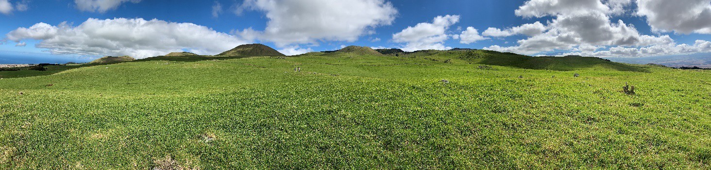
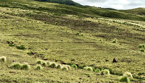
(Photo: View of the gently sloping ridges in windward Kohala, looking north to Maui.)
Since 2006, Michael Graves along with several colleagues has studied agricultural adaptations in windward Kohala using a variety of methods including LiDAR imagery, satellite and aerial photographs, historic maps and documents pertaining to land use, and archaeological field studies. These methods allow us to survey agricultural features and terraces at different scales 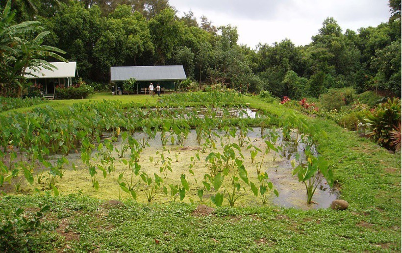 and locations, e.g., irrigated complexes within gulches and impermanent drainages and on ridge lands separating gulches. Although extensive 20th century sugar plantations in Kohala impacted many archaeological sites, combination of information sources (e.g., LiDAR, historic maps) allows us to verify the locations of ridge land loʽi that have been mostly obscured. With this information it is now possible to reconstruct networks of linked agricultural complexes and irrigation ditches extending over several kilometers of this landscape.
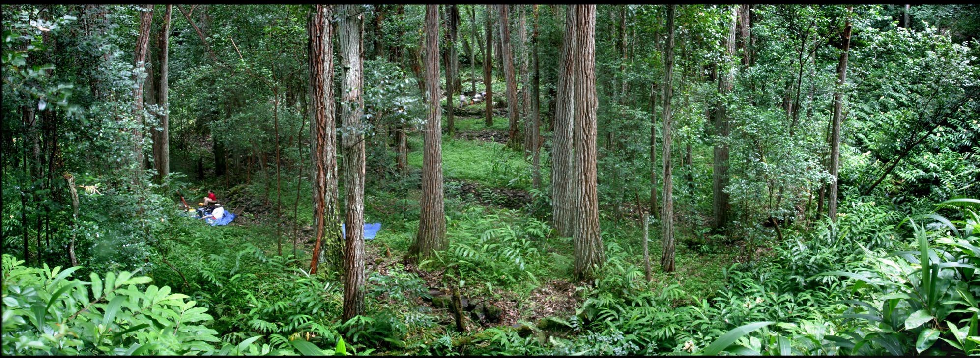
(Photo: Restored kalo loʽi at Konea o Kukui located on the west side of Niuliʽi Stream near Keokea Bay in Makapala Ahupuaʽa.)
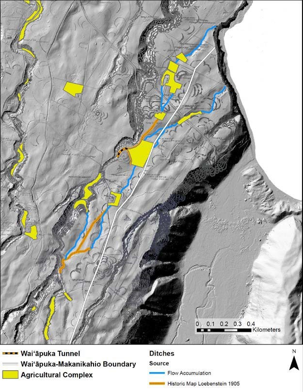
This map of Waiʽāpuka and its neighboring ahupuaʽa of Niuliʽi and Makanikahio illustrates a network of both kula and valley bottom pond field terrace complexes, along with terraces in several impermanent drainages all of which are connected by a series of irrigation ditches that pulled water out of Waikama Stream to feed complexes at lower elevations. These upper complexes are linked to those below by both drainages serving as ditches and formal ditches. Ditches that transported water across valley slopes were either dug into bedrock or in one case dug through bedrock to create a tunnel linking Waikama Stream with pond fields below the ridge top. A number of these irrigated agricultural networks occur in the eastern gulches of Kohala where lands suitable for farming in valley bottoms were limited. They appear to date later than most coastal complexes, likely constructed in the 16th to 17th centuries AD and would have required coordinated efforts on the part of multiple households and perhaps members of adjacent communities.
This work has been joined with recent research documenting several larger coastal agricultural complexes located within gulches that may have served or been built by aliʽi (chiefs), often whose ritual sites are located nearby or whose settlements were documented historically. We have also drawn upon the earlier archaeological work in Pololū Valley on the eastern edge of Kohala to reconstruct a system of irrigated agriculture in a large coastal marsh or pond and as terrace complexes at the base of the valley slopes with floodwater dryland farming along the lower portions of the valley. Excavations at several residential sites on a large sand dune at the coast have dated to as early as the 13th century AD, the earliest reliable date for initial Hawaiian settlement in Kohala.
Our work in windward Kohala includes the support and assistance of the University of New Mexico Foundation, University of Hawaiʽi at Mānoa, the National Science Foundation, the National Endowment for the Humanities, Kamehameha Schools, Vispassna Hawai‘i, New Moon Foundation, Surety, Inc., and local community members Nani and Don Swedsen, Brad Wiley, Mike Gomes and Fred Cachola. Colleagues who have worked in Kohala include Julie Field, Mark McCoy, Joseph Birkmann, Mark Oxley, Kekuewa Kikiloi, Kelley Uyeoka, Kamuela Plunkett, Kekoʽo Brown, and Stephen West. (Photo: Bedrock cut irrigation ditch, Niuliʽi Ahupuaʽa.)
